
Foothills Open Space Zones:
Planning, Designing, and Implementing the Future of the Foothills
Salt Lake City Public Lands presented a large scale Foothills Trail System Plan for the Foothills Natural Area in 2020. The Plan underwent a thorough review with evaluation and recommendations presented in 2024. Moving forward, the two following planning recommendations outline the specific next steps to implement the goals of the Foothills Trail System Plan.
- Identifying “Foothills Zones” for Comprehensive Recreation and Restoration Planning
- Adopting Planning, Design, and Implementation Phases for Foothills Zones
Identifying “Foothills Zones” for Comprehensive Recreation and Restoration Planning
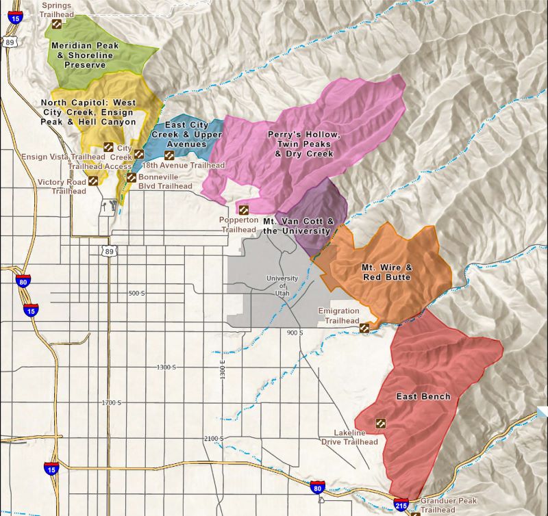
This map is for conceptual purposes only and does not account for land ownership complexities or legal boundaries.
Public Lands has identified 7 Foothills Open Space Zones for planning:
- North Foothills: Bonneville Shoreline Preserve, Meridian Peak, Jones Canyon
- North Capitol: Hell’s Canyon, Ensign Peak, West City Creek
- East City Creek: East City Creek, Meadow Trail, Upper Avenues above Terrace Hills
- Twin Peaks: Perry’s Hollow, Twin Peaks, Dry Creek Canyon
- Mt Van Cott: University bench, Mt Van Cott, West Red Butte Canyon
- Mt Wire & Red Butte: Red Butte, George’s Hollow, Mt. Wire, Wagner Peak, Lithograph Fork
- East Bench: Upper East Bench, East Bench Preserve, Parley’s Point
Recreation and Restoration Planning for each zone will include:
- Baseline area review of ecology, geography, vegetation, and geology of the zone.
- Evaluation of existing trail alignments for rehabilitation, realignments, or closure.
- Proposal of new trail alignments.
- Proposal of new amenities like seating, tables, signage, and wayfinding tools.
- Development of a communication and public notification process.
- Creation of a budget and maintenance plan.
Phase 1: Planning
Step 1: Initiating the Project
Public Lands will consult with experts and review existing plans for the zone. Public Lands will create a document that establishes the project’s goals and specific requirements.
Step 2: Baseline Area Review
Teams from Public Lands will visit the zone to evaluate the project area. Public Lands will coordinate with the associated land managers or owners.
Phase 2: Site Design
Step 3: Alternatives Development
Public Lands will develop options for trail alignment, restoration, and closures. Options will be presented to Key Stakeholders.
Step 4: Preferred Alternative
With input from the public and Key Stakeholders, Public Lands will choose the best options from the proposed alternatives.
Step 5: Design and Permitting
Public Lands will create a design for the project, which may require outside contractors. Public Lands will go through land ownership agreements, public engagement, and thorough environmental review ahead of trail construction.
Step 6: Zone-Specific Maintenance and Operations Plan
Public Lands will create a detailed plan for the protection of sensitive ecosystems in the zone. This plan will also address ongoing maintenance and future improvements.
Phase 3: Implementation
Step 7: Bidding and Contract
Public Lands will go through the bidding and contracting process for trail construction, land restoration, and amenity improvements, following Salt Lake City requirements. Implementation will happen in phases based on funding availability.
Step 8: Construction Process
Public Lands will oversee the construction process. Signage and other communication channels will keep trail users, adjacent residents, and the public informed about the construction process.