Foothills Plan
About the Foothills Plan
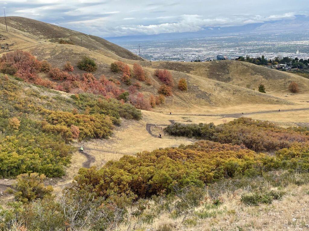
The Foothills Trail System Plan is a comprehensive vision for managing and improving the Foothills Natural Area’s trail network in a way that balances recreation with environmental protection. Approved in 2020 with extensive public and expert input, the plan aims to create a sustainable, enjoyable, accessible, safe, and low-maintenance trail system that offers varied experiences for users of different ages and abilities while safeguarding natural resources. After initial trail construction in 2020-2021 generated some public concern, the City paused trail construction to evaluate the Plan and make recommendations for future development. The evaluation and recommendations were completed in 2024 with creation of the Foothills Zone/ Development Process.
Zone Based Planning
The 8,000+ acres of foothills open space surrounding Salt Lake City’s northern and eastern urban edges is not a uniform landmass. The terrain, ecology, land ownership, and land use varies greatly across the area designated as the Salt Lake City’s Foothills Natural Area. While cohesive management practices determined by the Foothills Management Partnership will ensure consistency across the Foothills, zone-based planning was recommended to improve the development process for the Foothills Plan.
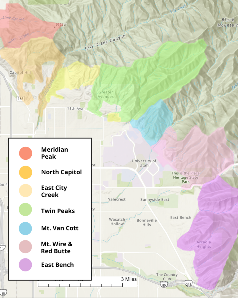
Seven zones have been identified in the SLC Foothills. Each zone boundary is roughly based geographical features like ridgelines or creeks rather than property lines to better reflect an inter-connected Foothills. The foothills zones are:
• Meridian Peak (Davis County to Hell Canyon)
• North Capitol (Hell Canyon to City Creek)
• East City Creek (City Creek to Perry’s Hollow)
• Twin Peaks (Perry’s Hollow to Dry Creek)
• Mt. Van Cott (Dry Creek to Red Butte Creek)
• Mt Wire & Red Butte (Red Butte Creek to Emigration Creek)
• East Bench (Emigration Creek to Parley’s Creek)
.
Foothills Zone Development Prioritization & Timelines
| Foothills Zone | Public Entity Landowners | Context/Timeline |
| East City Creek* | SLC** | This zone was where the majority of 2020-2021 trail construction occurred. The area has since been greatly impacted by multiple utility improvement projects. Planning and Design phases will be completed spring 2026. Implementation will begin summer 2026 and will be completed as funding and resources allow. |
| Twin Peaks | SLC, USFS, UofU | This zone includes tremendous variety with cultural landmarks, utility infrastructure, an extensive network of user-created trails, remote and sensitive ecology, and numerous large privately owned parcels. Planning and Design phases should be completed in fall 2026 with possible Implementation of new recreation and restoration projects in 2027. |
| North Capitol | SLC | This zone includes the west slopes of City Creek Canyon (outside of the protected watershed), Ensign Peak, and Hell Canyon, up to the Radio Tower Utility Road. Planning & Design will commence in 2027. Implementation is TBD. |
| Meridian Peak | SLC, USFS | This zone is more remote from SLC’s urban center but is directly accessible to North Salt Lake and Davis County. Much of Meridian Peak is on US Forest Service land and the Shoreline Preserve has a conservation easement held by Utah Open Lands. Planning & Design will commence in 2027. Implementation is TBD. |
| Mt. Van Cott | UofU, USFS | This open space in this zone is completely owned by the University of Utah and US Forest Service. As lead coordinating agency for the Foothills Management Partnership, SLC Public Lands will ensure consistent management and planning practices are followed but final approvals and timelines will be determined by the landowners. |
| Red Butte & Mt. Wire | UofU, USFS, UDSP | This open space in this zone is completely owned by the University of Utah, US Forest Service, and Utah Division of State Parks. As lead coordinating agency for the Foothills Management Partnership, SLC Public Lands will ensure consistent management and planning practices are followed but final approvals and timelines will be determined by the landowners. |
| East Bench | SLC, USFS, SLCo | This zone was not included in the original 2020 Foothills Plan. Existing use occurs between East Bench Open Space and Parley’s Canyon, while little use occurs north to Emigration Canyon. SL County purchased a large open space parcel in 2025 and the City continues to explore acquisition or easements in this zone to connect the final off-street section of the BST in Salt Lake City. Timing is TBD. |
**SLC is Salt Lake City municipality land managed by either the Department of Public Utilities or Public Lands Department.
Foothills Zone Development Process
Foothills Zone Development Process
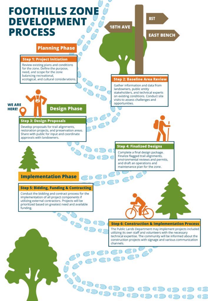
PLANNING PHASE
STEP 1: Project Initiation
- Define the purpose, need, and scope for the zone.
- Review existing environmental and recreational plans and documents for the zone.
STEP 2: Baseline Area Review and Documentation
- Expand dialogue with land manager and/or owners regarding purpose, need, and potential opportunities and challenges within this zone.
- Gather information from public entity stakeholders.
- Conduct multiple site visits to assess existing conditions to identify:
- Trail maintenance needs and new trail potential
- Unsustainable trail routes and restoration needs
- Ecological conditions including vegetation mapping, wildlife, and natural springs
- Natural area restoration and/or protections opportunities
- Trailhead and trail access conditions, wayfinding and interpretive signage challenges, and condition or need for-additional trail system amenities.
DESIGN PHASE
STEP 3: Design Proposals
- Create designs for alternative concepts and proposed actions for new or rehabilitated trail alignments and their intended uses; restoration areas and trail closures; and areas closed for preservation.
- Conduct site-specific environmental and cultural review of areas identified for proposed actions.
- Coordinate with land manager and/or owner for approval of the designs and actions including site visits if needed.
- Share proposed designs with the public to gain input on the proposed designs and actions.
STEP 4: Finalized Design
- Upon review of public input and land manager coordination, select and document the final design and actions.
- Fine tune preliminary designs suitable for project costing and final review.
- Conduct environmental review and public engagement for all project areas regardless of whether or not the project area includes any federal lands.
- Oversee necessary land ownership and property legal review related to the project.
- Oversee the development of a final design package encompassing all approved projects within this zone suitable for seeking competitive bids and/or guiding internal implementation.
- Draft an outlined maintenance and operations plan for routine inspections, repairs, enhancements, and the protection of sensitive ecosystems in the specific zone.
IMPLEMENTATION PHASE
STEP 5: Bidding, Funding, and Contracting
- Prepare and oversee the bidding and contract process for the implementation of all project components if utilizing external contractors. The bid process will conform to appropriate Salt Lake City procurement requirements. Projects will be prioritized based on greatest need and available funding.
STEP 6: Construction Process
- Public Lands may implement projects included in the final design package utilizing its own staff with the necessary technical expertise. This may include the use of supervised and trained volunteer community members.
- Public Lands will inform the public about construction using its existing communication channels and signage. Following the completion of the project, Public Lands will review the work and discuss any feedback or guidance that might inform future decision-making.