
General Plans
A general plan details the vision, policies, and framework developed by the community that guide growth and development in a neighborhood over a period of time, usually 20-30 years.
What is a General Plan?
A general plan usually includes four key components:

How are General Plans Implemented?
Ever wonder how general plans are turned into reality? View how an adopted general plan is implemented, this graphic helps explains how the City works with residents, businesses, developers, and other partners to make our plans come to life.
General Plan Boundaries
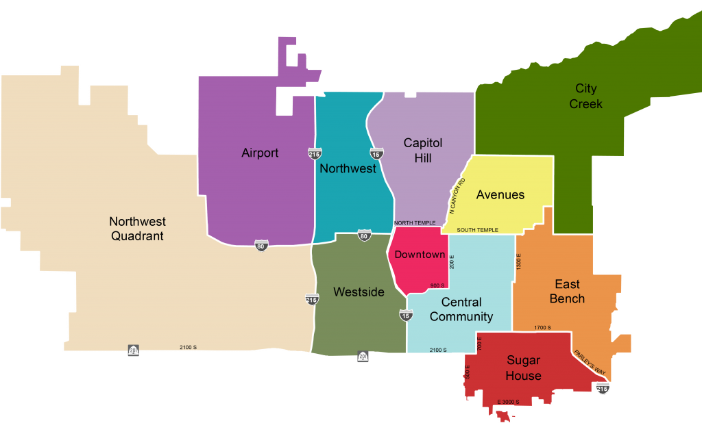
Citywide Plans
- Creating Tomorrow Together – Commission Report – Prepared 1998
- Community Preservation Plan – Adopted 2012
- General Plans Map – Prepared December 2005
- Salt Lake City Strategic Plan – Prepared December 1993
- Salt Lake City Urban Design Element – Prepared 1990
- Urban Forest Action Plan – Adopted 2023
- Water Conservation Plan – Adopted 2025
Housing
Transportation
- Connect SLC – Adopted May 2024
- Major Streets Plan – Adopted 2018
- Pedestrian & Bicycle Plan – Adopted 2015
- Transit Plan – Adopted 2017
- Transportation Plan – Adopted 1996
- Transportation Action Plan – Adopted 2000
Neighborhood Plans
Avenues
- Avenues Plan – Adopted July 1987
Capitol Hill
- Beck Street Reclamation Framework and Foothill Area Plan – Adopted September 1999
- Capitol Hill Plan – Amended 2001
Central Community
- Ballpark Station Area Plan – Adopted October 2022
- Block 42 Plan – Adopted 1990
- Central Community Plan – Adopted November 2005
- 400 South Livable Communities Project (Transit Oriented Development) – Adopted October 5, 2012
- East Central Community Small Area Plan – Adopted December 1992 (Revised 01/93)
- East Central Neighborhood Plan – Adopted December 1984
- East Central Neighborhood Plan Addendum – Adopted 1990
- East Downtown Neighborhood Plan – Adopted 1990
- Holy Cross Medical Campus Plan – Prepared June 1993
- St. Joseph Villa – Block 4-5 East Waterloo Subdivision Plan – Adopted November 1992
- 1300 East University District Area Plan – Adopted March 1991
City Creek
- City Creek Plan – Adopted April 1986
Downtown
- Downtown Plan – Adopted May 2016
- Downtown in Motion – Adopted 2008
- Library Square Block Plan – Adopted September 2002
East Bench
- East Bench Existing Conditions Report – Completed February 2014
- East Bench Plan – Adopted February 2017
- Parley’s Way Corridor Plan – Adopted February 2017
Northwest Community
- Northwest Plan – Adopted January 1992
- North Temple Boulevard Plan – Adopted 2010 (Revised 2023)
- Northpoint Small Area Plan – Adopted November 2023
- Rose Park Small Area Plan – Adopted 2001
Northwest Quadrant
- Northwest Quadrant Plan – Adopted August 2016
Sugar House
- Circulation and Streetscape Amenities for Sugar House Business District – Adopted February 2014
- Future Land Use Map Amendment for former Sugar House Fire Station Ordinance – Adopted March 2022
- Local Link Plan – Adopted February 2023
- Sugar House Circulation Plan – Prepared 2013
- Sugar House Plan – Adopted November 2001 (Updated 12/05)
- Sugar House Street Car Update to Plan – Adopted June 2016
- Sugar House Streetcar Phase 2 Alternative Analysis – Prepared 2013
- 21st and 21st Neighborhood Plan – Adopted November 2017
Transportation
- Major Streets Plan – Adopted November 2018
Westside
- Westside Plan – Adopted December 2014
- 9 Line Corridor Plan – Adopted March 2015
Future Land Use Plan Maps
Most adopted plans include a “future land use” map specifying the intended future land use of properties. For convenience, most recently adopted future land use maps are available on the City’s Future Land Use Plan Maps webpage.
Please note that not every plan with a future land use map is included on the map webpage but are instead available as digital documents from this webpage. Please see the Citywide and Neighborhood Plan sections above for a complete list of adopted plans and links to those plan documents.
If you require additional information, please contact us at [email protected] or 801-535-7700.
Salt Lake City Corporation is committed to ensuring that its digital content is accessible to all users. If you need an ADA accommodation, please submit a Request an Alternative Format form at least 48 hours in advance. Available alternative formats and services may include braille, large print, audio recordings, sign language interpreters, or other auxiliary aids and services.