
Salt Lake City Foothills Trail System Plan
— Quick Links —
Project Description
A Vision for Sustainable Recreation in the Foothills Natural Area
The Foothills Natural Area consists of approximately 6,000 acres of canyons, open sagebrush grasslands, and scrub-oak woodland bordering the northern and eastern limits of Salt Lake City. The Foothills are a patchwork of open space properties owned by the City, the University of Utah, Utah State Parks, and the US Forest Service, none of whom have had an active management plan for the region. The Salt Lake City Department of Public Lands took the lead to initiate and envision the 2020 Foothills Trail System Plan (“the Plan”) to develop a managed trail system that would be continuously reviewed, revised, and improved upon to balance the environmental needs of the Foothills with the recreational demands of our residents and visitors. The Plan’s vision is to provide a variety of recreational trail and cultural experiences for diverse ages and abilities while managing the Foothills’ environmental resources for future generations.
Project Details
Project Location
Salt Lake City Foothills Natural Area
Project Manager
Tyler Fonarow
tyler.fonarow@slc.gov
Project Status
Active
An evaluation of this plan was recently conducted.
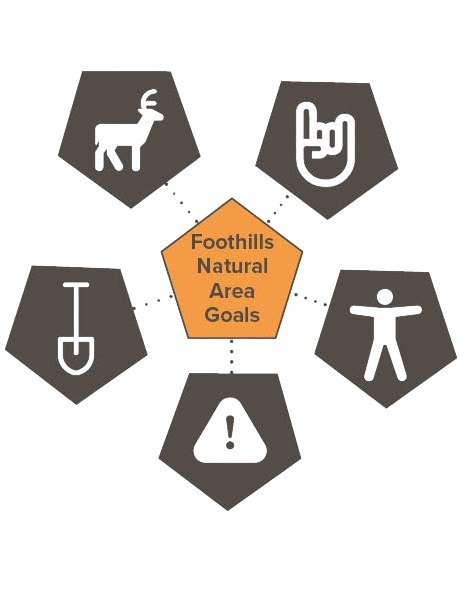
Plan Vision & Goals
PROJECT VISION: The Foothills Natural Area will provide a variety of recreational trail experiences for diverse ages and abilities while managing the Foothills’ environmental resources for future generations.
The Plan outlines five primary goals:
- Environmentally Sustainable: Trails avoid sensitive habitat, minimize erosion, and make efficient use of available natural lands while protecting the wild and scenic nature of the Foothills landscape.
- Enjoyable: Trails cater to a diversity of recreation types and users, and a variety of desired experiences.
- Accessible: Trails are accessible to a broad audience of beginner to immediate trail users, including families, seniors, and people with disabilities.
- Safe: Trail user conflicts are mitigated and minimized through trail design and use regulations.
- Low-Maintenance: Trails drain water naturally, follow contours instead of fall-lines, and encourage users to remain on-trail, minimizing maintenance efforts.
Salt Lake City Foothills Plan History
Creation of the Plan and Public Input (2016-2018)
An extensive review of existing local and regional studies was conducted for the creation of the Plan, including the Salt Lake City Open Space Plan (1992), various University of Utah master plans (2007, 2008, 2011), and numerous tangential plans such as Emigration Canyon, East Bench, City Creek Canyon, neighborhood plans, and Wasatch Cache Forest Travel Plan. The planning team also researched best practices for urban open space land conservation and recreational trail system development from areas around the west, such as Boulder, CO, Boise, ID, and the San Francisco Bay Area. A thorough review of the existing conditions included identifying the existing trail network of user-created trails and the Bonneville Shoreline Trail, mapping topography, trail grades, and profile slopes.
The Public Lands team and its planning consultant, Alta Planning & Design, conducted extensive community public outreach between 2016 and 2018. Dozens of stakeholder interviews were conducted, and over 3000 residents gave input through surveys or online mapping tools. A timeline and narrative description of public input is listed on p. 35-43 of the Plan, which can be found in the pdf at the bottom of this page.
Phase I Implementation & Plan Evaluation (2020-2021)
Between 2020 and 2021, the City’s Public Lands Department began implementing the Plan’s first phase. Phase I trail construction occurred on Salt Lake City open space properties in lower City Creek, above the Avenues neighborhood, and in Popperton Park. The City identified approximately 15-20 miles of newly built and pre-existing trails to integrate into the Foothills Trail System. The current Foothills Trail System map is linked here.
Plan Evaluation
Due to some public concern regarding trail building impacts and straying from the Plan, the City paused Phase I at approximately 85% completion, in addition to any future trail construction, to formally evaluate Phase I construction and update the Plan to ensure that future phases meet the Plan’s vision and goals. The City hired three consultants to evaluate the Plan independently from their various areas of expertise.
- SWCA, an environmental consultant, was hired to complete a baseline pre-NEPA ecological and cultural report that will inform future trail development and conservation areas.
- Natural area recreation planner SE Group and their subcontractors, trail industry experts Kay-Linn Enterprises and Applied Trails Research, were hired to complete a thorough evaluation of the Plan and Phase I implementation and provide a report with recommendations.
- Lastly, Salt Lakes brought on DEA Inc., a civil planning communications consultant, to assist with community engagement and bolster communications efforts to deliver effective messaging to the City’s constituents.
Salt Lake City Foothills Plan Recent Updates
(2022-2023)
Early Findings & Reports
SWCA conducted extensive stakeholder meetings and collected data from January 2022 through May 2023. Recordings of their pre-NEPA preview meeting and final report meeting can be found here:
- SWCA Foothills pre-NEPA report preview discussion (March 21, 2023)
- SWCA Foothills pre-NEPA final report presentation (May 31, 2023)
- SWCA Foothills pre-NEPA Final Report (September 2023)
The SE Group team commenced their work in September 2022. They created an internal technical committee and stakeholder group of City staff from various departments including Public Lands, Public Utilities, Engineering, Transportation, Planning, Communications, Sustainability, Police, Fire, 911, the Mayor’s Office, and the City Council Office. These internal city meetings and trainings occurred in fall 2022. The technical subcontractors led week-long field visits with the Public Lands team in October 2022 and April 2023 to review existing field and trail conditions.
SE Group shared a preview of their Foothills Trail System Plan & Phase I Review and Future Recommendations Update on June 5, 2023 and submitted their final report in February 2024. Links to the meeting recording and documents can be found here:
Community Engagement
- October 2022: SE Group leads the City’s Foothills Technical Committee through a week of professional training and Foothills site visits. Here’s a sneak peek of some “Trail Science & Design 101“
- January 2023: external stakeholder presentations and listening sessions with community councils and planning groups; non-profit and advocacy groups including Save Our Foothills, Save Our Canyons, and SLC Trails Alliance; accessibility and adaptive recreation groups; Native American Leader Working Group; underrepresented resident groups
- February 2023:
- SE Group’s technical specialist team hosted a webinar with Q&A on “Best Practices for Soft-Surface Sustainable Trail Design.”
- PNUT Foothills Subcommittee hosted USU Recreation & Tourism professor Jordan Smith at the Public Lands building to present on his team’s research in the Tri-Canyon (Big & Little Cottonwoods and Millcreek) area for the US Forest Service on trail user trends and needs.
- Public Lands staff shared monthly reports and conducted Q&A at Greater Avenues Community Council meetings as well as Mayor’s and City Council offices staff meetings. Public Lands published monthly or quarterly Foothills newsletters.
- May 11, 2023 – Tyler Fonarow and Foothills Park Rangers Haley Long and Kyle Webster presented an update “ Building Trails; Building Trail Culture –How Salt Lake City is learning to simultaneously develop a “world-class trail system” and educate its “world-class users”” at the Utah Trails Forum in Richfield, UT.
Foothills Trail System Plan PDFs

Complete Project Timeline
2016-2017
- June 2016 – June 2017: Trail User Pre-Project Online Survey
- August – October 2017: Existing Conditions Analysis & Review of Relevant Data & Documentation
- October 2017: Stakeholder Interviews
- November 2017 – January 2018: Public Outreach and City Events & Activities
- December 2017: Presentations to select Community Councils
2018
- December 2017 – January 2018: Online Mapping & Solicitation of Public Feedback
- March 28 and April 2, 2018: Public Open House
- Spring – Summer 2018: Plan Review by City Boards & Commissions
- July – October 2018: Plan Review by Internal City Departments, Land Managers and Agencies
2020
- January 2020: Plan Review by Council
- March 3, 2020: The plan was voted on and formally approved by City Council.
- June 2020 – May 2021: Phase I trail construction
2021
- May 2021 – current: Conduct evaluation of Phase I construction and create updated procedures for the Plan.
- 2021 – Current: Develop plans for trail and ecological maintenance; wayfinding and interpretive signage; Foothills Park Ranger program and trail etiquette campaigns; create MOUs with property owners Utah State Park (This is the Place) and University of Utah; collaborate with US Forest Service on their Tri-Canyon Master Plan in preparation for NEPA process for trail development on federal lands; design and implement major trailhead improvements and signage and amenities at all trail access points