This Online Open House will provide an opportunity for you to review information about the proposal and provide any questions or comments. This Open House meeting will be an electronic meeting pursuant to Salt Lake City Emergency Proclamation No. 2 of 2020 (2)(b).
Zoning Map (“Rezone”) and Master Plan Amendment
FR-3 to FB-UN1 Zoning and Master Plan Amendment
November 29, 2021 Update: The applicant for the rezone has submitted Planned Development and Subdivision applications to accommodate their Zoning Map and Master Plan Amendment applications. The below information is out of date and has been superseded by the new application materials on the new webpage.
March 22, 2021 Update: The applicant has updated their rezone and master plan proposal, by revising their requested zone to the SR-1 (Special Development Pattern Residential) Zoning District. The applicant is no longer requesting the FB-UN1 zone for the property. The regulations for the SR-1 zone can be found on the City’s Zoning Ordinance webpage here. The applicant has also provided an updated site plan with some modifications and clarifications to setbacks and heights. Their updated packet of materials can be downloaded from the following link, please see the first two pages for the updated material:
Although the 45-day public input deadline of March 18th has passed, additional written comments can still be provided up until the day of the Planning Commission public hearing for the proposal. At this time, the proposal has not yet been scheduled for a Planning Commission public hearing.
February 1, 2021 Update: The applicant has updated their rezone and master plan proposal with a revised conceptual site plan and additional supporting documentation. Their packet of updated application materials can be downloaded here:
The updated information is being reviewed by City Staff and will be scheduled for a Planning Commission meeting at a later date. Please provide any comments on the revised proposal by March 18, 2021. A Planning Commission public hearing may be scheduled after that date. Any comments provided last year on the original design will still be provided to the Planning Commission when a public hearing is scheduled for the item.
Anyone who has directly e-mailed the Planning Division regarding this proposal will receive an e-mail directing them to this website for the updated information. They will also receive an e-mail when the public hearing is scheduled.
October 19, 2020 Update: The applicant is currently updating their proposal and there is no tentative Planning Commission public hearing date at this time. When updated materials are received they will be sent out to the community council, as well as to anyone who has e-mailed comments on the proposal. This page will also be updated with those materials
Petition Number: PLNPCM2020-00334/00335
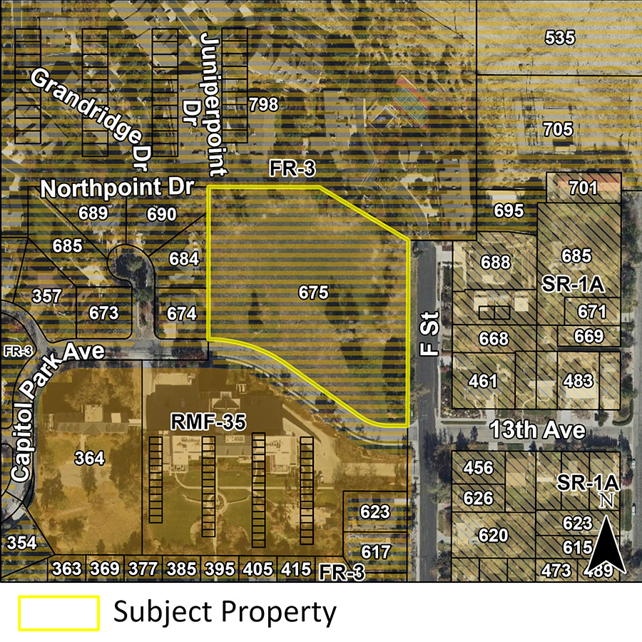
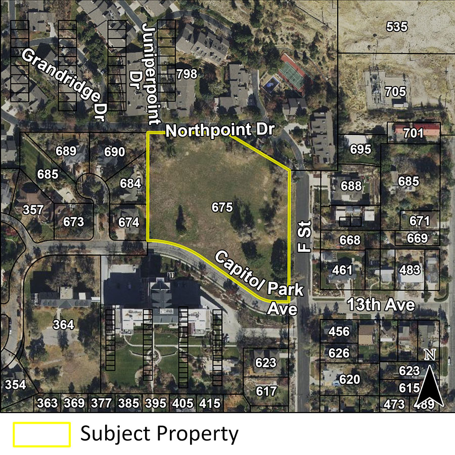
Address: 675 N F Street
Current Zone: FR-3/12,000 “Foothills Residential District
Requested Zone: FB-UN1 “Form Based Urban Neighborhood 1
Peter Gamvroulas, representing Ivory Development, has initiated a petition to amend the zoning map and master plan designation for the property at 675 N F Street. The applicant is requesting to change the zoning of the property from the FR-3/12,000 “Foothills Residential District” to the FB-UN1 “Form Based Urban Neighborhood 1” zoning district. Both zones primarily only allow for low-scale residential development but have differing regulations for such development, including regulations on allowed housing types, setbacks, and building design. The FB-UN1 zone allows for single-family detached, single-family attached (row house), and two-family/duplex dwellings. The FR-3/12,000 zone only allows single-family detached dwellings.
The current Avenues Community Master Plan’s Future Land Use map (adopted in 1995) matches the current zoning designation of FR-3/12,000. The applicant is requesting that the Future Land Use map be amended to a designation that aligns with the proposed FB-UN1 zoning.
The property is currently vacant and is approximately 3.2 acres in size. Under the current FR-3/12,000 zoning, the property could be developed for 11 single-family detached homes.
The applicant has provided a narrative explaining their request and has included a concept plan with their petition showing a conceptual design scenario under the proposed FB-UN1 zoning. These can be downloaded from the Additional Information section below.
Project Location
Address: 675 N F Street
Key Facts
The FR-3/12,000 and FB-UN1 both primarily only allow for low-scale residential development.
Both zones have similar height allowances, allowing up to 28′ in the FR-3 zone and 30′ (limited to 2.5 stories) in the FB-UN1 zone.
Use and density regulations differ between the two zones:
- The FR-3 zone is a single-family residential zone, allowing for one single-family detached dwelling per 12,000 square feet of land. The property is approximately 139,392 square feet in size, allowing for up to 11 single-family detached homes to be built on the property.
- The FB-UN1 zone allows for single-family detached, two-family, or single-family attached (row house/townhome) development. The zone regulates development primarily by building form rather than use or density. Building forms include the “urban house” (single-family appearance but up to two units), “two-family” (two units/duplex), “cottage” (small single-family dwellings), and “row house” (single-family attached) forms. Each building form has a different lot size requirement, ranging from 1,500 square feet to 3,000 square feet per building form. The number of units per square feet of land (density) will vary depending on the mix of building forms and dwelling units per building form, but the resulting density allowance is higher than the FR-3 zone.
Lot width requirements also differ. The FR-3 zone requires 80′ of lot width for a single-family dwelling, whereas the FB-UN1 zone ranges from a minimum of 15′ to 30’ depending on building form.
Front setbacks in both zones are required to be the average setback of a block face. If there is no existing block face setback, the FR-3 zone requires a min. 20′ front setback versus a min. 10’ in the FB-UN1 zone.
The FR-3 zone has several unique regulations intended to reduce the visual impact of development in the foothills, including grade change limitations, driveway location limits, and roof/exterior color restrictions. It also has special allowances for additional building height on steep grades.
Both zones allow for one accessory dwelling unit (ADU) in addition to single-family detached dwellings on a property. In the FB-UN1 zone an ADU is also allowed in addition to two-family detached dwellings.
Compilations of the zoning regulations for each zone and their associated land use tables can be downloaded here:
- FR-3/12,000 Zoning Code Excerpt – This includes an excerpt of the applicable base regulations for development in the FR-3 zone and the associated land use table listing allowed uses.
- FB-UN1 Zoning Code Excerpt – This includes an excerpt of the applicable base regulations for development in the FB-UN1 zone and the associated land use table listing allowed uses.
Existing Applicable City Plans
In evaluating amendment proposals City staff evaluates the proposal against applicable adopted City Master Plan documents. This proposal is located in the City’s Avenues Community Master Plan (1987) and will be analyzed with regard to the policies in that plan. That plan can be downloaded here: Avenues Community Master Plan
The Future Land Use map and associated designations in that plan generally match the current zoning, but the map in that plan was officially superseded by the zoning map in 1995. The zoning map currently serves as the Avenues Future Land Use map, rather than the map in that document. The applicant is requesting to amend the “Future Land Use” map to a designation that aligns with their proposed FB-UN1 zoning designation. Those maps can be downloaded below under Additional Information.
City Staff also evaluates amendment proposals against applicable Citywide Master Plans, including plans such as Plan Salt Lake and the City’s Five Year Housing Plan.
Review Criteria
The City’s Planning Staff will evaluate the proposal against adopted policies and regulations and provide a recommendation to the Planning Commission. The below are criteria used to analyze a proposed zoning amendment:
- Whether a proposed map amendment is consistent with the purposes, goals, objectives, and policies of the city as stated through its various adopted planning documents
- Whether a proposed map amendment furthers the specific purpose statements of the zoning ordinance
- The extent to which a proposed map amendment will affect adjacent properties
- Whether a proposed map amendment is consistent with the purposes and provisions of any applicable overlay zoning districts which may impose additional standards
- The adequacy of public facilities and services intended to serve the subject property, including, but not limited to, roadways, parks and recreational facilities, police and fire protection, schools, stormwater drainage systems, water supplies, and wastewater and refuse collection.
Additional Information
- Information sheet – Summary of the proposal from City Planning staff
- Applicant’s Narrative and Concept Plan February 2021 Update – Updated concept plan and additional supporting documentation provided by the applicant
- Applicant’s Narrative (June 2020 Version) – Narrative from the applicant explaining their rezone request
- Applicant’s Concept Plan (June 2020 Version) – Applicant’s concept design for the property under the proposed FB-UN1 zone from June 2020. See 2021 update above for revised concept plan.
- Applicant’s Concept Plan – Applicant’s concept design for the property under the proposed FB-UN1 zone
- Map of the Current Zoning – This map shows the current surrounding City zoning
- Map of the Future Land Use Designations – This map shows the future land use designations for the property (This map matches the current zoning map as the 1987 Avenues Community Master Plan’s FLU map was superseded by the zoning map in 1995.)
- FR-3/12,000 Zoning Code Excerpt – This includes an excerpt of the applicable base regulations for development in the FR-3 zone and the associated land use table listing allowed uses.
- FB-UN1 Zoning Code Excerpt – This includes an excerpt of the applicable base regulations for development in the FB-UN1 zone and the associated land use table listing allowed uses.
Next Steps
The Planning Division is in the process of obtaining public comments on this petition to help identify concerns and issues from the public. The process for a zoning amendment (“rezone”) includes multiple steps and public hearings. The following additional public meetings will be held regarding this rezone. Nearby residents and property owners will receive mailed notice for each of the below public hearings.
- Planning Commission: Will hold a public hearing and make a recommendation to the City Council (Date TBD. Will not be before March 18, 2021)
- City Council: Will hold a public hearing and make a decision (Dates TBD)
The City Council is the final decision maker on this rezone proposal.
Public Comments and Questions
The public comment period closed on March 18, 2021. For additional information on this project please contact the staff planner.
Daniel Echeverria // daniel.echeverria@slcgov.com // 385-226-3835
During and following this comment period, the Planning Division will evaluate the proposal against the applicable zoning standards, taking into consideration public comments as they relate to the standards, and develop a recommendation for the Planning Commission.