It is our priority to ensure our reliable high quality drinking water for our community. We are stewards of our water resources and our environment, from the Wasatch Mountains to Great Salt Lake. Factors such as climate change and drought have the potential to impact our region’s water supplies and exacerbate other water challenges. Water conservation is one of the best ways to extend our water supply, ensure resiliency during drought, and address declining water levels in the Great Salt Lake.
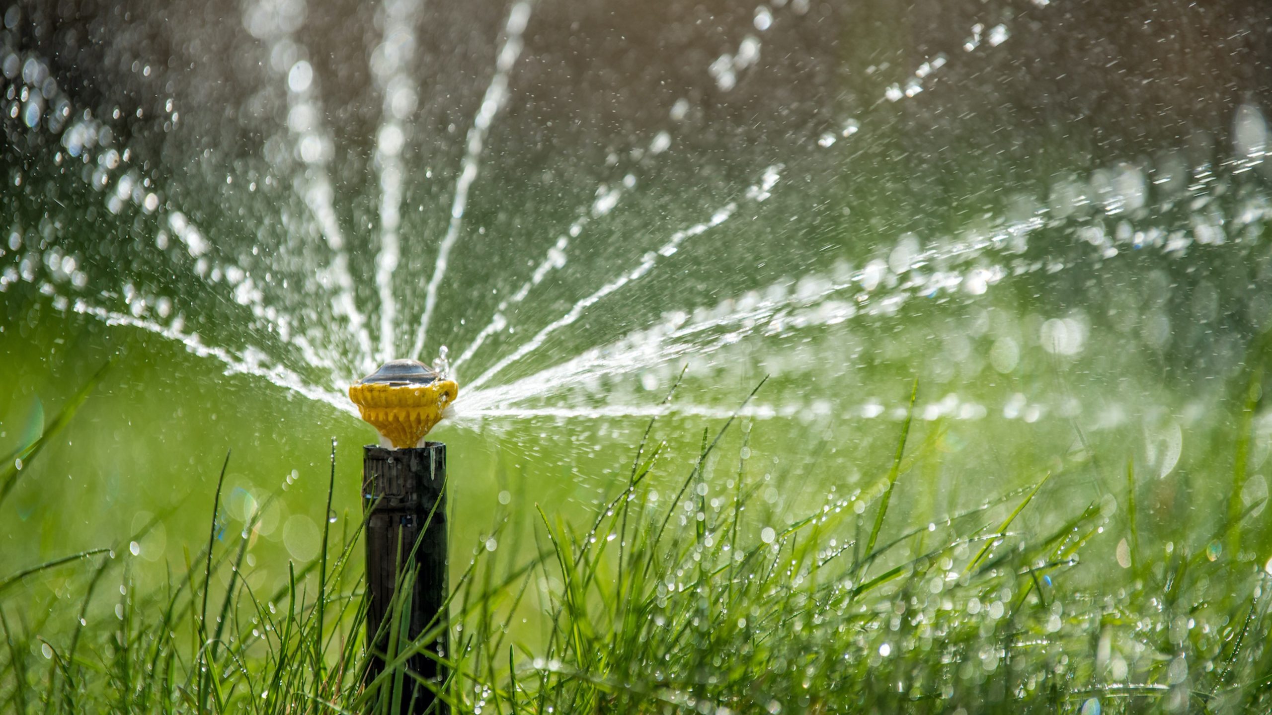
According to the Environmental Protection Agency and the Utah Division of Water Resources, up to 60% of residential water use is applied to outdoor landscapes. This number tells us that we can make great strides in conservation by simply irrigating appropriately or modifying the landscaping at our own homes.

Salt Lake City is introducing a new conservation program, developed in conjunction with Utah State University (USU) WaterMAPS™ team, which is designed specifically for the communities we serve. Salt Lake City’s application of WaterMAPS™ software puts valuable information into the hands of residents in Salt Lake City’s water service area. Residents with water service accounts will be able to access USU WaterMAPS™ reports for individual residential property locations and identify opportunities to conserve water.
It can be easy to overwater your yard without even realizing it. Many people get in a routine of watering, without considering factors such as weather and how much water plants really need during different times in the irrigation season. Oftentimes people do not truly see the results of overwatering until they check their utility bills and water usage in the summer months.
What is WaterMAPS™?
Working in conjunction with Utah State University (USU), Salt Lake City is able to offer our residents the opportunity to participate in a new conservation program, directed at helping identify true landscape watering needs and match water usage accordingly. We are proud to introduce USU’s Water Management Analysis and Planning Software (WaterMAPS™), for residential locations within Salt Lake City’s Water Service Area.

Utah State University WaterMAPS™ is an analytic software program developed to assist water managers and customers in understanding patterns of landscape water use, identifying locations with the capacity to conserve water applied to landscapes, and guiding water conservation efforts.
The science behind WaterMAPS™
The WaterMAPS™ program integrates parcel data, land cover data, water meter data, and weather data to calculate what is called the “Landscape Irrigation Ratio (LIR).” LIR values indicate how efficiently water is being used to maintain your landscape and whether the water use at your property is outpacing the water needs of your landscape. LIRs are calculated on both an annual and a monthly basis.
What is an LIR and how does it represent outdoor water use efficiency?
The Landscape Irrigation Ratio (LIR) compares how much water you use on your landscape to how much water your landscape needs. The LIR is estimated outdoor water use (derived from meter data) divided by landscape water need (derived from vegetation needs and local weather data). An LIR of 1 means that you are watering close to what your landscape actually needs, an LIR of 2 indicates you are watering about twice as much as your landscape needs, and LIRs over 3 indicates an application of three times as much water as is needed (suggesting excessive landscape water use). Your annual and monthly LIRs can be used to track how well you avoid overwatering and become more efficient over time. To learn more about the methods, click here.
Elements of your WaterMAPS™ outdoor water use report
This report is individualized to your property. It will:
- show the property address and location
- characterize the land cover on your property and estimate how much water your landscape needs
- illustrate your property’s annual LIRs for the past five years (2018-2022)
- enable you to interactively investigate monthly LIRs for each of those five years and see potential water savings in gallons
- direct you to more information
Sample Report: You can view a generic sample report here
Access your WaterMAPS™ report by visiting our payment page and logging in to your account.
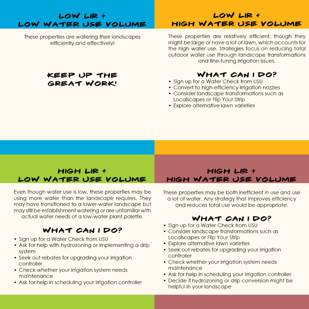
Water Conservation Strategies
There are different ways you can contribute to landscape water conservation efforts:
1. If you have high LIRs, you can increase your water use efficiency. Look for LIR information in your WaterMAPS™ report.
2. If you use high volumes of water, you can reduce the overall amount of water you use. Check your water bill to see if your water use during the irrigation season puts you into Block 3 or Block 4 water rates.
Look at both your water use efficiency (LIRs) and the amount of water you use to see what you can do. The graphic below provides some suggestions.
Next Steps
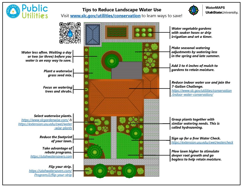
Here are some additional tips to reduce your landscape water use.
FAQ
What is WaterMAPS™?
WaterMAPS™ (Water Management Analysis and Planning Software) is a custom software application developed by a team of Utah State University (USU) researchers to promote water conservation and water efficiency in urban landscapes.
Can anyone else see my WaterMAPS™ report?
Other than select staff with the Salt Lake City Department of Public Utilities and the USU WaterMAPS™ team, no one else can see or has access to your report.
What imagery is used for WaterMAPS™?
WaterMAPS™ uses publicly available digital aerial imagery, including National Agriculture Imagery Program (NAIP) data.
How do I use/read/understand my WaterMAPS™ report?
Click here for more information on how to interpret the report.
How do I use my WaterMAPS™ report to conserve water?
We have identified specific strategies and tips depending on your LIR and water use levels to help you improve efficiency and reduce water waste. See information above.
Is my WaterMAPS™ report updated every month?
Currently, WaterMAPS™ is not updated monthly. Your WaterMAPS™ report shows the past five years of your landscape water use data. It will be updated again after the end of this irrigation season.
What is 'ET' and how is it calculated?
ET stands for evapotranspiration, the evaporative process by which water is transferred from the land to the atmosphere by evaporation from the soil and other surfaces and by transpiration from plants. WaterMAPS™ uses localized reference evaporation (ETo) rates that are modified by plant factor adjustments for the vegetation types on your property to determine your landscape’s water need. ETo is based on climactic conditions like solar radiation, temperature, humidity, and wind.
It is important to remember that a landscape’s water need changes with the season. ETo generally goes up in the summer and down in the fall. In the Salt Lake Valley, ETo generally increases starting in early May, peaks in July and early August, and then declines throughout the fall. This is why you might hear messages about changing your sprinkler controller at different times of year even when the temperatures may be the same.
[accordion title="Is WaterMAPS™ only being applied to residential properties?"]
The WaterMAPS™ report is currently for residential water users who have accounts within the Salt Lake City Department of Public Utilities’ Service Area. We are expanding the program to include water users at commercial and institutional (including public) properties.
Where can I see my WaterMAPS™ report?
Visit the SLCDPU bill page and log into your account.
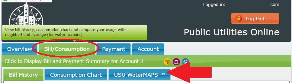
Once there, select “Bill/Consumption” and you will see the USU WaterMAPS™ menu tab.
Is there a place I can learn different ways to water my yard better?
Yes, we are so glad you asked! Check out our water conservation page.
What if I think my LIR is wrong?
No worries! We have done our best to review and evaluate the data so that we can give you the best information available. However, the large databases we work with can contain errors. If you think there might be an error in your report, please reach out to us and let us know why you think might be incorrect. We will review or update your assessment, if needed. Contact us at:
USU WaterMAPS™ team E: watermaps@usu.edu
Salt Lake City Department of Public Utilities E: water.conservation@slcgov.com